Drone mapping, an innovative application of unmanned aerial vehicles (UAVs), has revolutionized various industries, from agriculture to construction and beyond. This cutting-edge technology utilizes drones equipped with specialized cameras and sensors to capture aerial imagery and data, enabling precise mapping and analysis. Understanding how drone mapping works unveils its significance in revolutionizing traditional mapping methods.
Drone Technology Essentials
At the heart of drone mapping lies sophisticated technology. Drones utilized for mapping purposes are equipped with high-resolution cameras, LiDAR (Light Detection and Ranging) sensors, GPS systems, and often thermal or multispectral imaging capabilities. These components work in unison to capture detailed imagery and collect essential data during flight.
Data Acquisition and Image Capture
During a mapping mission, drones follow predefined flight paths, capturing high-resolution images or scanning the terrain using LiDAR technology. The onboard cameras or sensors collect data points, creating a detailed and accurate representation of the landscape below. The images are captured from various angles and altitudes to ensure comprehensive coverage.
Georeferencing and Stitching
Once the images or data are collected, the next step involves georeferencing and stitching. Georeferencing aligns the captured images with precise geographic coordinates, ensuring accuracy in the final map. Subsequently, specialized software stitches these images together, creating a seamless mosaic or 3D model of the area, allowing for detailed analysis and visualization.
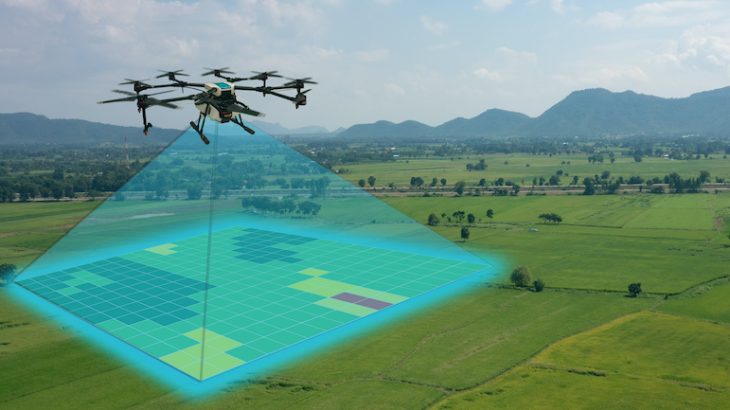
Data Processing and Analysis
The amassed data goes through meticulous processing using advanced software. This stage involves applying algorithms to process the imagery, creating orthomosaics (geometrically corrected aerial images), digital elevation models (DEMs), or point clouds. These outputs provide valuable information about elevation, terrain features, vegetation health, and more, facilitating in-depth analysis.
Applications Across Industries
Drone mapping finds diverse applications across various industries. In agriculture, it aids in precision farming by assessing crop health, monitoring irrigation, and optimizing yield. In construction and infrastructure, it assists in surveying, site planning, and monitoring progress. Moreover, it’s instrumental in environmental monitoring, disaster management, and urban planning, offering invaluable insights for decision-making.
Enhanced Accuracy and Efficiency
Compared to traditional mapping methods, drone mapping offers unparalleled accuracy and efficiency. The high-resolution imagery and detailed data collected enable professionals to make informed decisions swiftly. Additionally, the speed of data acquisition and analysis significantly reduces project timelines and costs, making it an attractive choice for industries seeking precision and speed.
Regulations and Ethical Considerations
The widespread adoption of drone mapping also brings forth regulatory and ethical considerations. Governments worldwide have established guidelines and regulations governing drone usage to ensure safety, privacy, and responsible operation. Adhering to these regulations is crucial to mitigate risks and maintain ethical standards while harnessing the potential of drone mapping.
Future Innovations and Advancements
As technology continues to evolve, the future of drone mapping looks promising. Advancements in AI and machine learning are expected to further enhance data processing capabilities, allowing for real-time analysis and predictive modeling. Moreover, miniaturization of sensors and improved battery life may lead to more compact and efficient drones, expanding their applications even further.
Environmental Conservation and Monitoring
One of the most promising aspects of drone mapping lies in its potential for environmental conservation. The technology enables precise monitoring of ecosystems, wildlife habitats, and natural resources. From tracking changes in vegetation cover to assessing the impact of climate change on landscapes, drones equipped with specialized sensors offer a non-intrusive and comprehensive way to gather crucial environmental data. This data aids scientists, conservationists, and policymakers in making informed decisions for preserving biodiversity, managing natural resources sustainably, and mitigating environmental threats.
Potential Advancements and Integration
Looking ahead, the future of drone mapping holds exciting possibilities. Integration with other emerging technologies like Internet of Things (IoT) devices and advanced analytics promises even more sophisticated applications. Imagine drones collaborating with ground sensors or satellite data to create a holistic understanding of landscapes in real-time. Moreover, advancements in autonomy and AI-driven algorithms may lead to drones capable of autonomous flight planning, obstacle avoidance, and adaptive data collection strategies. These innovations could further streamline mapping processes, enhance accuracy, and expand the scope of applications across industries, driving efficiency and innovation in numerous fields.
Drone mapping stands at the forefront of modern mapping techniques, offering unparalleled capabilities in data acquisition, analysis, and visualization. Its impact spans across industries, providing invaluable insights for decision-making and problem-solving. As technology advances and regulations evolve, the potential of drone mapping to revolutionize how we perceive and interact with our environment remains limitless. Looking for surveying experts in Australia? Call Flat Out Surveying, they make use of unmanned aerial vehicles (UAV) to guarantee the most accurate results.


